Healthy Streets Initiative
Austin has always been known as a city on the move. Even in the sweltering Texas heat, it is not uncommon to find people out and about no matter the time of day.
After gyms, exercise facilities and many businesses closed to stop the spread of COVID-19, the number of Austinites using the streets for daily activity increased drastically. In order to maintain social distancing policies and allow residents to maintain a healthy and active lifestyle, Austin City Council directed an initiative on May 11 called the Healthy Streets Initiative.
A “Healthy Street” is a segment of streets or routes that offers helpful connectivity to parks and trails. Additionally, these streets provide an alternative to spaces that may be overcrowded as people seek outdoor recreation.
Laura Dierenfield, program consultant for Healthy Streets and active transportation, says the spaces are designed for people to renew the sense of normalcy on a day-to-day basis while we are living in these strange times.
“These spaces are meant to be helpful places to get outside and get fresh air safely,” Dierenfield says. “We were intentional about trying to connect existing infrastructures and trails and hope people are able to even discover new parts of the community and new places to run or go for a ride they have never explored before.”
The idea for the Healthy Streets Initiative came after many peer cities began to experiment with the idea of creating street space for physical distancing as COVID-19 swept the nation. The first city to adopt plans to create safer space for movement was Oakland, California.
On April 10, the Oakland mayor and Department of Transportation announced the start of the Oakland Slow Streets plan. According to the City of Oakland, the plan designated 74 miles of neighborhood streets to bikes, pedestrians, wheelchair users and local vehicles only across the city.
Shortly after, several more cities followed suit — among them, Denver, Portland and Seattle. Since then, many more cities across the nation have added measures to allow for safe use of streets for pedestrians and riders.
Austin’s Healthy Street Initiative is very similar, Dierenfield says.
“Healthy streets are made up of traffic-control devices that allow for local residents, their guests and emergency response to continue to navigate in a car but deter that through traffic from moving through a neighborhood,” Dierenfield says. “This way, the space becomes more hospitable for people to walk side by side or for a child who might be learning to ride a bike while maintaining appropriate physical distance from one another.”
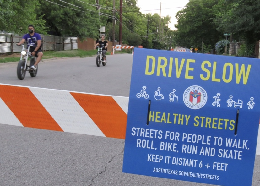
Around parts of the city, barricades with Healthy Street signs help set intentions and communicate with street users what to expect and how to use Healthy Streets. There are also signs which indicate certain streets are open to local traffic only and show alternate routes to get around.
The first round of Healthy Streets were implemented in May. Determined by a number of factors, the City Council chose streets that served a purpose and provided benefits to as many people in the city as possible.
The city’s first batch of Healthy Streets includes:
- Bouldin Ave. / S 3rd St. / Garden Villa Ln. from Banister Ln. to Barton Springs Rd.
- Comal St. from Manor Rd. to Lady Bird Lake
- Country Club Creek Trail extension (Trail, Wickersham Ln., Oltorf St., Pleasant Valley Rd., Ventura Dr., Madera Dr.) from Mabel Davis Park to Lakeshore Dr.
- Riverside Dr. from Lamar Blvd. to South 1st St.
- Pleasant Valley Rd. from Canterbury St. To S. Lakeshore Blvd.
Austin City Council is working to continue to improve and expand the initiative as the need for more space to safely exercise develops. One of these ways is by creating an interactive online map and forum for residents to track the Healthy Streets Initiative and provide feedback of their own.
After over 400 responses from communities across Austin, a second wave of streets were released to be added in July.
The city’s second batch of Healthy Streets includes:
- Avenue G from 38th Street to 56th Street
- Belfast Drive from Broadmoor Drive to Cameron Road
- Marsh Drive, Leo Street, Seminary Ridge Drive and Whispering Oaks Drive from West Slaughter Lane to West William Cannon Drive
“After this, we plan to look at other areas based on community suggestions,” Dierenfield says. “We know there are communities that have been disproportionately impacted, and we want to provide healthy space across the whole city.”
Dierenfield says that for as long as physical distancing is necessary, Healthy Streets will continue to be a supplement for fitness outlets that are unable to operate as normal.
While this is a temporary moment in time, Dierenfield says the Austin Transportation Department is looking at how to translate what everyone has learned into a permanent benefit for the community.
“There are lots of lessons we can learn from this initiative moving forward and as we continue to try to create space for the moment,” Dierenfield says. “We are certainly looking at how street space can better serve pedestrians and people getting to and from transit to be able to get around safely and coexist to a degree with all users on the street.”
- ATX
- austin roads
- family time
- going outside
- healthy streets
- healthy streets initiative
- more time outside
- pandemic