The Great Outdoors
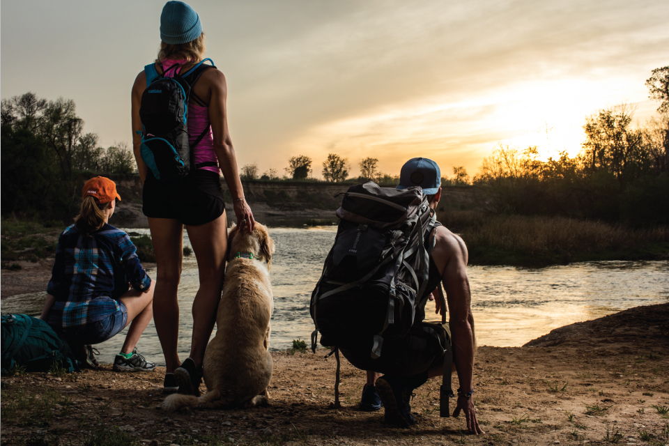
Looking for an adventure? We’ve picked our favorite camping spots, challenging hiking trails and day trip escapes. The best part is that you don’t even have to leave Texas.
Big Bend National Park
By David Leffler

PHOTO BY WESTON CARLS
I draw my breath in slowly, careful not to disrupt the waves of tranquility pouring over me as I look out toward the Chisos Mountains. The Chisos are a gorgeous, dusty ruby red, glowing from the setting sun to my back. It’s 6:45 in Terlingua, Texas, a former quicksilver mining town that has since been resettled by a hodgepodge of cowboys, hippies and adventure seekers. I step back from my perch outside the Starlight Theatre—a repurposed bar that was part of the ghost town left behind when the miners left in the 1940s—and drink my beer, taking in long gulps of the surrounding desert landscape.
The Starlight is bustling with denim-clad locals out for a communal drink after another day out in the West Texas sun. The mood is spirited. Though I’ve found the prime spot for people watching and a good story, I didn’t drive eight hours and nearly 500 miles for a watering hole; I came here for 800,000 acres of towering mountains, endless skies, picturesque vistas, and mesmerizing views. I came here for Big Bend National Park.
At First Glance
Big Bend’s rugged charm is obvious. The park’s territory sprawls southeast of Terlingua, its arid climate and harsh terrain disguising a thriving wildlife population that includes Mexican black bears, mountain lions, roadrunners, coyotes and over 450 species of birds. The Rio Grande snakes along the interminable miles of cacti and red rocks, separating the U.S. from Mexico by as little as a few feet at certain points. If you find the right spot, you can take in marshes, plateaus, white-water rapids, cliff faces and desert dust all in a single glance.
For the Adventurous
Although it’s a great spot for artistic inspiration, Big Bend is best enjoyed by doing, not viewing. The park’s many outdoor attractions include camping, horseback riding, over 150 miles of hiking trails, mountain biking, natural hot springs, canoeing, ATV tours and white-water rafting. There are several outfitters in Terlingua that provide guides and gear, but by far the largest is the Far Flung Outdoor Center. I was fortunate enough to go on an overnight canoe trip into the famed Santa Elena Canyon with Austin Alvarado, Far Flung’s tour manager, and a few of the company’s newly-arrived guides.
An ideal time to push off from shore is around 9 a.m., usually greeted by clear skies and shallow green waters. The Rio Grande is still and carries you through the canyon’s cool embrace. The 1,500-foot rock walls hug us on both sides of the winding river as an air of serenity casts over the land. To the left is Mexico; to the right, the U.S. The canyon yields little signs of life other than canoe paddling and a few turtles sunbathing on nearby logs, uniformly stretching their necks out side by side. Direct sunlight is scarce from the sliver of sky hanging overhead, but every so often you’ll come across a sunny spot to momentarily provide warmth as you make your way upstream.
After hours of canoeing, you’ll encounter potential camping spots on high ground where the Rio Grande makes a sharp left turn. The riverbank’s grass is soft and fertile, making it the perfect place to rest after hours of being active. The evening’s high point comes when night falls and the dark sky emerges, blanketed by thousands of stars and swaddled by silence.
One for the Road
Leaving Big Bend is a little sad when your excursion has ended and it’s time to go home. That doesn’t mean the journey is over, though. Perhaps the most exciting part of the experience is the 120-mile stretch of FM 170 running along the Rio Grande. Known simply as the River Road by locals, this drive will leave you slack-jawed and short of breath as you gaze out toward the mahogany mountaintops above the Rio Grande’s river basin. Be sure to pull over and soak it in if you have a moment—you’ll miss it when the West Texas sun has melted from your rearview mirror.
Garner State Park
By David Leffler

PHOTO BY TRAVIS PERKINS
The icy surface of the Frio River licks the bottom of the kayak, edging nearer and nearer to my outstretched arms as my boat makes its way downstream. Antique trees hug the shoreline on either side of me, their thick roots crawling into the water to join my voyage. It’s a beautiful, brisk spring morning in Concan, Texas—the only kind they have around here. A deer eyes me suspiciously from afar before averting its gaze and dashing into the woods, its tail elegantly bobbing with every step.
Welcome to Garner State Park, a vibrant Texas Hill Country oasis nestled beneath the palisades of the Edwards Plateau. Opened in the early 1940s in the wake of the Great Depression, this place has long served as a refuge for those in search of solitude, escape and rejuvenation. Its tranquil presence and lush vegetation make Garner the perfect weekend getaway spot—and Texas’ most popular state park, attracting around 350,000 attendees each year.
Breath of Fresh Air
The first thing that stands out about Garner is how alive it is. From its towering bald cypress trees—which can get up to 120 feet tall and 1,000 years old—to the thriving wildlife of deer, squirrels and turkeys that call it home, there isn’t a dull moment here. Bird watching is a popular activity, and for good reason: the park plays host to hundreds of different birds, including the golden-cheeked warbler, which is as beautiful as it is rare. The warblers have been an endangered species since 1990. Garner’s surprisingly fertile lands make all this possible—a product of its location within several canyons that are fed by cool, moist winds. These airstreams fuel its diverse plant population and give it a far greener appearance than the rest of the Hill Country.
Blue Planet
Much of Garner’s near 2,000 acres center around the Frio River, giving its visitors plenty of ways to get wet. Depending on how strong the river is flowing, campers have the option to tube, kayak, paddleboard and swim—but be ready! The Frio stays at a refreshing 68 degrees, living up to its name. These cool waters are especially enticing during the Texas summer, when temperatures hit triple digits and a good swimming hole is worth more than gold. The park also has plenty of hike-and-bike trails and offers free fishing for those who’d rather relax along its riverbanks with a few friends or a good book.
Pack Your Dancing Shoes
Though the park’s beauty is unquestioned, perhaps its most famous attraction is “The Dance.” Rumored to have sprung from moonlit dances held by the park’s construction workers in the early 1940s, Garner’s outdoor pavilion plays host to summer dances for hundreds of friends, families and couples. Line dancing is especially popular, with classics like “Puttin’ on the Ritz,” “Whip It,” and “Rockin’ Robin” belting from the park’s renowned Wurlitzer jukebox. There’s also some 2-stepping music for anyone looking to strut their Texas stuff.
For the City-Slicker
Not keen on staying in a formal campsite? Garner’s got you covered, casual campers. With 17 cabins and 37 screened shelters among its 418 available spots, it’s a great place for family trips and people of all ages. The park also has several on-premise dining halls that can accommodate weddings, reunions and work functions.
Lay of the Land
Garner didn’t become the most popular state park for its looks and facilities alone. A huge pull factor is its proximity—only about three hours from Austin. While that sounds daunting at first glance, those 169 miles are nothing compared with the 437 out to Big Bend. And if you’re looking for the ideal Texas Hill Country moment, you’ll find it around here—the drive near Garner is especially beautiful, with winding roads and rolling green hills sprawling as far as the eye can see. Nearby towns like Utopia, Uvalde and Leakey are also great day trip destinations if horseback riding, hunting, hang gliding or paragliding fit your fancy. Regardless of your taste or your patience for driving, a few days out on the Frio and some time under the Concan stars will have you only thinking about only one thing: planning your next trip out here.
Guadalupe Mountains National Park
By Gretchen Goswitz
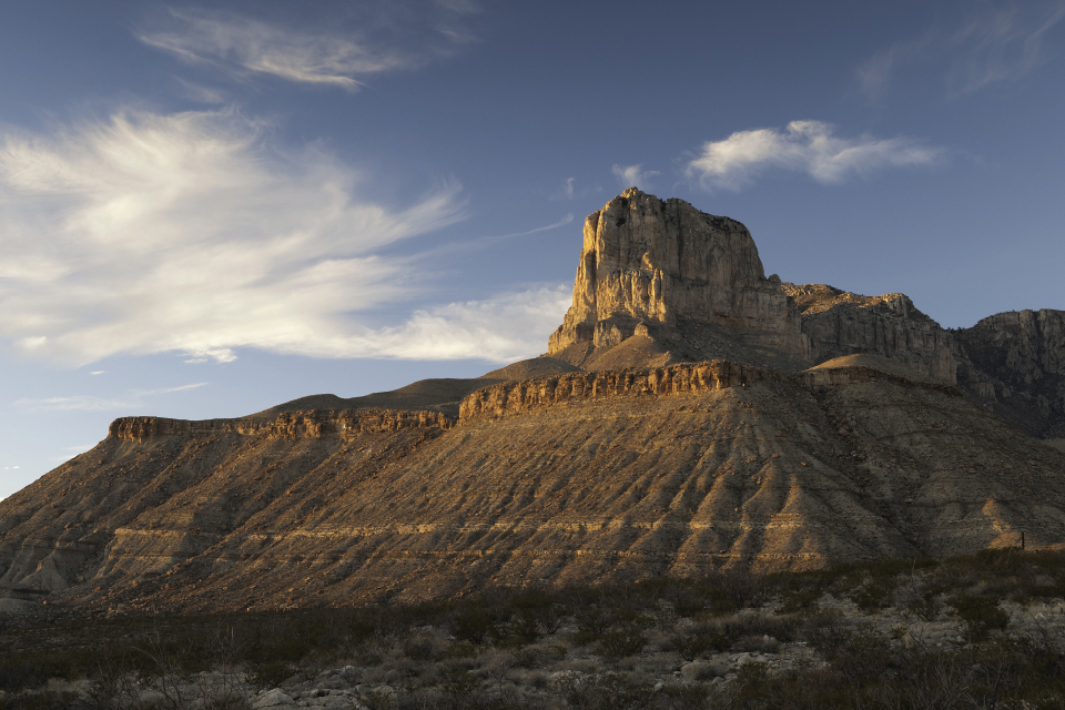
When you’re gazing down from a peak that is so high up you’re leveled with the clouds, there’s a surrounding ethereal beauty that makes even the most strenuous hike well worth the trip. Any fear of heights quickly vanishes, despite standing 8,749 feet above sea level. The vast country of mountains and desert plains boast breathtaking views that are to die for, and yet, make you feel like it’s the closest we’ll get to heaven while feeling so alive.
Somewhere between heaven and Texas, and nestled along the border of New Mexico, Guadalupe Peak is the state’s highest elevation. Actually, Guadalupe Mountains National Park fills the podium, claiming the top three highest points in Texas.
A paradise for hikers, Guadalupe Mountains National Park is one of the few picturesque places in the state that rotates through four definite seasons. The park received 18 inches of snow at Dog Canyon this past winter, and happens to be a popular spring break destination due to the ideal camping weather. Fall is the busy season, courtesy of maple and hardwood trees showing off foliage and dramatic color changes that light up the desert.
A Rich History
Although archaeological evidence suggests GMNP has been occupied by humans for over 10,000 years, the park experience is a celebration of West Texas early settlers. The Smith family were early pioneers to the area, braving the weather conditions and harsh environment, navigating life without a previously established community. They staked their claim in the area by staying in those boundaries the longest and the 1880s Joseph Smith Frijole Ranch still stands as a historic attraction to visitors interested in learning about the early inhabitants.
The Guadalupe Mountains have also been home to native tribes—particularly the Mescalero Apaches—for centuries. The local tribes still have a presence in the area, which is another cause for celebration. In early May, the park assists in the production of an annual mescal roast is hosted by the Apaches who still occupy the area.
The Guadalupes are one of four mountains the Mescalero people hold sacred. According to tradition, the tribe once gathered at the summit of El Capitan to survive a great flood that was said to have submerged the world. At the spring celebration, the agave is baked or roasted, and repurposed into many different dishes to pay homage to the food source that the Mescalero consumed with nearly all of their meals.
Crossing the Border
Prolong your adventure by stopping around the nearby attractions. The Guadalupe Mountains are so far west that New Mexico is an easy access. On the New Mexico side of the border, travelers can check out Roswell and embrace the alien conspiracy that put this small town on the map. Additionally, the Living Desert Zoo in Carlsbad exhibits more than 40 species of animals and hundreds of species of plants native to the Chihuahuan Desert. On the Texas side, take in the scenery in Van Horn or explore the vibrant community of El Paso.
It’s largely a hiking park, and if the mountainous scenery isn’t the only part that’ll grab your interest, the geology and fossils along the various routes are riddled with ancient organisms that have long been extinct. The Permian Reef System is the same ridge in Carlsbad Caverns (tucked away in New Mexico), and due to geological forces, the ridge rose and exposed a section of it but still spans the gateway between Texas and New Mexico.
Backcountry Excursions
The GMNP is vast and abundant with hiking trails and scenic campgrounds. First-time visitors may struggle to decide on a trail or location within the park to explore. More manageable trails, like the Smith Spring Loop, are only two and a half miles long. But for backpackers who want to stay a while, an optimal experience is available by hiking through Pine Springs, spending the night at that camp, and then crossing through Tejas Trails to Dog Canyon. For an easier trek, Pine Springs to McKittrick is a popular way to go, and showcases older hunting shacks built in the 1930s by West Texas settler Wallace Pratt.
Ten small backcountry campgrounds without amenities are available to those who pick up a free permit at park headquarters located at Dog Canyon or Pine Springs. Water is not always readily available, so it’s recommended backpackers and campers prepare by securing about a gallon for each day. The combination of high peaks and strong sunshine is ruthless, so layers and sunblock are a must. If you prefer an RV weekend campout rather than a primitive camping experience, less rustic spots are available in McKittrick Canyon and Devil’s Hall. Regardless of which option you choose, you’ll be surrounded by wildlife and may even catch a glimpse of javelina, elk, roadrunners, mule deer, mountain lions and more.
Davis Mountains Preserve
By Gretchen Goswitz

West Texas is characterized by miles upon miles of desert and arid landscapes, and although they’re picturesque—especially around the more mountainous regions—few to none compare to the scenic, biologically diverse oasis that is the Davis Mountains Preserve. Rising above the Chihuahuan Desert, the range forms a unique “sky island” that is home to rare plants and animals that could only thrive in this kind of ecological isolation.
The Davis Mountains comprise a unique and limited ecosystem. The system is slow to recover from impacts inflicted by humans such as overgrazing, habitat fragmentation through improper ranching practices and overuse of the water resources. These threats in particular, in addition to the attention many of the rare birds and plants need to grow and live in this environment, led to necessary action taken by The Nature Conservancy. Over time, nearly 100,000 acres of the Davis Mountains have been permanently conserved, but only 33,000 acres are collectively known as the Davis Mountains Preserve.
Because the preserve is so remote, this area happens to host some of the darkest night skies in the continental United States. For the science buff, it’s one of the best places for deep space observation. For the romantic, it’s one of the best places to revel in the opulence of stars that isn’t visible back home.
Priorities
The conservation of a landscape-scale “sky island”
The preservation of West Texas’ ranching legacy by keeping a large and historical part of that heritage intact
Safekeeping the dark skies surrounding University of Texas McDonald Observatory
Camping at the Preserve
Tent camping on the preserve is available to the general public during open events. Pick-up campers, pop-up trailers and small RVs is allowed but there are no hook-ups and generator use is prohibited. Dogs are not allowed.
As a compromise to protect the area and allow visitors to bask in the beauty of it, The Nature Conservancy has scheduled open days and weekends. Camping, hiking, biking, equestrian, picnics, photography, birding and other outdoor activities are available on selected days this year.
April 16 – Open Day
May 21 – Open Day
July 1-3 – Open Weekend
August 12-14 – Open Weekend
October 15 – Open Day
December 9-11 – Open Weekend
The Davis Mountains Preserve is located approximately 25 miles northwest of Ft. Davis on Hwy. 118—about 10 miles past McDonald Observatory and about one quarter mile past the Lawrence E. Wood Picnic Area
Lost Maples State Natural Area
By Jayme Lamm

Located about 150 miles west of Austin in Vanderpool, Texas, is Lost Maples State Natural Area, which has an isolated strand of uncommon Uvalde bigtooth maple (the largest strand east of the Guadalupe Mountains). Visitors can enjoy picnicking, camping, backpacking, sightseeing, hiking, photography, bird watching, fishing, swimming and nature study—it’s a park that has it all, and makes for a perfect weekend getaway from Austin. The park definitely has busy seasons (sometimes requiring a year in advance for booking), but the busiest times are October to November and March to May (to go along with the changing of the seasons). Nearby attractions include Garner State Park, Hill Country State Natural Area, Kerrville-Schreiner Park, Camp Verde, Lake Medina, and the towns of Utopia and Bandera. Last year’s unseasonably warm weather and excessive rainfall did not yield a good year for the maple leaf color, so visitors are hoping this year is better.
A Trip for the Fall
The optimal time to visit Lost Maples is generally the last two weeks of October through the first two weeks of November to get the best views of the changing colors. When the seasons change, the foliage is breathtaking with its show of fall colors. Lost Maples’ dramatic fall foliage is attributed to the high concentration of maple trees within the area. Although maples can be found in a variety of areas throughout Texas, few dense concentrations exist as they do here, hence the name—Lost Maples. Visitors are asked to stay on designated trails as walking can damage the beautiful trees because of their shallow root system. Part of Lost Maples’ appeal is its year-round outdoor recreational opportunities, including hiking, birding, fishing, paddle sports, and mountain climbing. However, Lost Maples’ biggest draw remains the changing of the leaves each fall, when the park gets extremely crowded. In fact, it gets so crowded in the fall that visitors must book a year in advance, rather than a month in advance during spring and only a week in advance during the off-season. If you’re able to plan your visit during a weekday, it won’t be nearly as crowded, and definitely worth a day off from the office.
By the Numbers
Elevation at Lost Maples ranges from 1,800 to 2,250 feet. There are 11 miles of trails for hikers, so don’t forget to pack your hiking shoes and other essentials for the trail. The average annual rainfall is 35.1 inches and the average temperature for July is 94 degrees. The entrance fees are $6 for adults and children 12 and younger are free.
Prime Place for Bird Watching
Lost Maples can be separated into three major habitat categories: grasslands and scrublands; mixed evergreen and deciduous escarpment woodlands; and floodplain and streamside woodlands. The floodplain woodlands boast the greatest variety of birdlife, which is what makes Lost Maples so popular among bird watchers from all over Texas. All three of these habitat types are easily accessible by trails. The park also contains numerous species of plants, which has become popular with visitors.
Reimers Ranch Park
By Jayme Lamm

PHOTO BY TRAVIS PERKINS
Reimers Ranch Park is only a half hours drive from Austin, which makes it the perfect day trip for many reasons, especially the panoramic views it provides of the Texas Hill Country. The 2,400-acre park, the largest in Travis County, is in Dripping Springs and is a nature lover’s dream combination of pristine parkland, open space and reserve land fit for various activities. Since it’s a day use park only, there is no camping allowed. The park boasts almost three miles of continuous frontage along the Pedernales River and is the largest parkland acquisition in the history of Travis County. The land, which was previously owned by Milton and Joy Reimers, was acquired by Travis County in 2005.
Dress the Park Part
There is so much to do at Reimers Ranch; it’s truly an active person’s playground. Activities include rock climbing, mountain biking, swimming, fishing, hiking and equestrian trail riding. Probably the most popular is mountain biking, with over 18 miles of trails winding through Texas Hill Country, but riders beware that trails are often closed after a heavy rain to help preserve the integrity of the trails. If you’re an avid biker, you’ll surely love the rolling landscape. The trails are rated similarly to a ski run system, with a green circle for beginners, blue square for intermediate, and black diamonds for advanced. Be sure to ask the park ranger at the entry system for a trail map.
Back-up Plan
Reimers Ranch has become a popular backup swimming hole when Hamilton Pool Preserve is too crowded and has long wait times. After parking at the River Bend lot and taking a short walk down a paved road, you’ll find yourself on the shores of the Pedernales River. The swimming hole has plenty of room for relaxing and taking in all the wonderful sights and sounds of the park, but visitors should note there is no shade along the river. Remember to pack your sunscreen, hats, an umbrella and ample drinking water, as there is no drinking water anywhere on the trails.
The Secret’s Out
The Central Texas rock-climbing community caught on a long time ago that Reimers has some world-class climbing fit for all levels, and is one of the biggest attractions to the park. The majority of the climbs are on the cliff lines that head off to the right and left of the creek, parallel to the river. Many of the climbs overlook the Pedernales River, which provides excellent scenery and a post-climb cool down in the summer when it gets incredibly hot.
Bird-Watchers’ Delight
Although most head to Reimers Ranch for their rock climbing, mountain biking or white bass fishing, many avid bird-watchers flock there during cooler months. The ranch hosts monthly bird walks the first Saturday of the month from October through April, and it is known for its wide variety of winter sparrows over the winter.